
The world’s oceans have consistently been breaking daily heat records since early 2023, a yearlong fever that has climate scientists, coral reef experts and even hurricane forecasters concerned and dismayed.
In the main region of the Atlantic Ocean where hurricanes develop, water temperatures are “absolutely stunning,” said Brian McNoldy, a senior research associate studying hurricanes at the University of Miami’s Rosenstiel School.
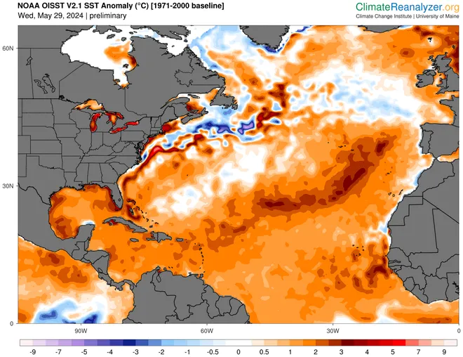
Hotter oceans and sea surface temperatures are like an octane boost for hurricane season, cranking up the fuel that drives the formation and intensity of hurricanes and tropical storms as they move over the ocean. Warmer-than-normal waters in the Atlantic, the Caribbean and the Gulf of Mexico play starring roles in all the seasonal outlooks for the Atlantic hurricane season beginning June 1.
“The whole tropical Atlantic is warmer than its ever been for this time of year,” McNoldy told USA TODAY on Thursday. It’s sitting at temperatures normally not seen until mid-August. And, “the Caribbean is going crazy.”
The record daily average temperatures in the Atlantic north of the equator have been broken only by a four day period between April and May, when the average water temperature dropped to a tenth of a degree below a daily record set last year.
“And all of that’s coming on the heels of 2023, which was warmer than it ever was for this time of year,” McNoldy said. “Now we’re breaking 2023 records. So, not great.”

When ocean temperatures were record warm during last year’s hurricane season, vertical wind shear over the Atlantic, created by shifting winds from the El Niño in the Pacific Ocean, likely put a damper on at least some of the potential hurricane activity.
The season still wound up busier than average with seven hurricanes and 20 named storms, the fourth most active season on record. This year, with that protection gone as the weather pattern likely shifts to a La Niña, which reduces wind shear over the Atlantic, seasonal hurricane forecasters fear the worst.

Warmer-than-normal ocean temperatures also contribute to massive bleaching on the world’s coral reefs and are thought to play a role in the increase of sargassum seaweed mats that blanket and stink up beaches and in harmful algal blooms and fish kills. Experts also say warmer water temperatures in the Gulf are enhancing the moisture available for storms and helped contribute to the increase in tornado activity this spring.
How hot are the oceans?
Global average sea surface temperatures recently took what appeared to be a little steeper dive than typical for this time of year when the hemispheres are changing seasons, but it’s still the warmest average temperature on record for the date.https://www.usatodaynetworkservice.com/tangstatic/html/usat/sf-q1a2z330306dc3.min.html
The average temperature in the North Atlantic on Thursday was 72.14 degrees, 2.34 degrees above the 1982-2011 mean, according to the Climate Reanalyzer at the University of Maine‘s Climate Change Institute, which uses NOAA data.
Average water temperature in the Atlantic’s main development region for tropical cyclones – along the latitudes between 10 and 20 – is almost a full degree warmer for May than any other year since records began in 1982, said Phil Klotzbach, a senior research scientist at Colorado State University who leads its seasonal forecast team. And that’s 2.52 degrees above the 1991-2020 average.
Get the Daily Briefing newsletter in your inbox.
The day’s top stories, from sports to movies to politics to world events.
Delivery: DailyYour Email
Hot oceans spell trouble for hurricane season
Colorado State and the National Oceanic and Atmospheric Administration and others point to the warmer water as a key influence in their seasonal hurricane outlooks. It’s part of the reason why the outlooks from both contain the greatest number of storms they’ve ever projected.
“Although record-setting sea surface temperatures alone don’t guarantee a busy hurricane season, they do strongly influence it,” wrote Michael Lowry, a hurricane specialist at WPLG Local 10 in Miami, in a column for Yale Climate Connections.
Warm water fuels hurricanes, contributing an influx of heat and moisture that lifts into the air and helps build the massive cloud structures that form and intensify hurricanes.
Areas of warmer-than-normal water in the Gulf of Mexico, for example, are credited with supercharging storms like Hurricane Katrina. Warm water is thought to boost intense rainfall in storms like Hurricane Harvey and help trigger rapid intensification, such as the sudden explosion of intensity in Hurricane Idalia before it made landfall on Florida’s Gulf Coast last year.
When wind shear is low and water temperatures are high, there’s little to inhibit the cloud structures that do form from gaining strength and intensity. Conversely, as hurricanes move northward in the Atlantic over cooler water, they begin to lose their oomph.https://www.usatodaynetworkservice.com/tangstatic/html/usat/sf-q1a2z330306dc3.min.html
Why is the Atlantic so hot and how long will it last?
Scientists aren’t sure why we’ve seen the lingering spike in average ocean temperatures. So far, at least, no great consensus explanation has emerged, McNoldy said, and he doesn’t expect to see a single explanation.
Scientists attribute the warming in large part to the heat the oceans have absorbed as a result of human-caused increases in fossil fuel emissions. But other factors may also have played a role, including El Niño, air quality improvements, and even potentially an influx of moisture from the eruption of the Hunga Tonga volcano in early 2022.
Weak trade winds over the past couple of months have helped reinforce the warmer-than-normal sea surface temperatures in the main hurricane development region in the Atlantic, Klotzbach told USA TODAY.
Even if the region were to warm at its slowest observed rate between now and September, it would still be the second warmest September for the region, trailing only 2023, Klotzbach said. The region would be .54 degrees ahead of the other years in the top six – 2020, 2010, 2005 and 2017 – based on NOAA records available since 1981.
Looking forward into the summer, McNoldy doesn’t “see any reason to think the warm water anomalies will just go away and we’ll get back to average.”
“It just doesn’t look like that’s in the cards,” he said.
While it’s too early to know whether heat content in the Atlantic will keep breaking 2023 records or be somewhere under that, McNoldy said there’s plenty of room to be under the 2023 records “and still be ahead of every other year.”
Once peak hurricane season starts in July and August, when water temperatures typically reach their maximum and you’ve got the abnormally hot temperatures on top of that, “that’s when it’s not just hurricanes that are supercharged,” he said. “Then you have to worry about killing off the rest of the coral too.”
Water temperatures at some stations in the Florida Keys and Everglades National Park already have hit 90 degrees.
Author:: Bagombeka Job
Credit:: USA TODAY